

![]()
o Indianola - A Town Perfectly Situated on the Bay
o Indianola & The Chihuahua Road
o James McCoppin - 1st Calhoun County Judge
o Robert E. Lee's Lighter Side
o Confederate License Plates Honor Texas History

Indian Point
Now Indianola, she's only a ghost
on the jagged shoreline of the old Texas coast
where the howling wild wind has raised up its hand
and buried her dreams in the sand...Brian Burns - "Indianola"
A Brief History of Indianola, Texas...
In the year 1875 life was good at Indianola, Texas. It was ten years after the Civil War, the Yankee reconstruction government was gone years ago, and ship traffic to the port was growing steadily. In this frontier seaport town, there were travelling baseball teams, 4th of July Celebrations, fire brigades, churches, schools, theatres, billiard parlors, and photography studios. Seafood, was particularly cherished. It was also the year of the first hurricane of two that would devastate the town and lead to its abandonment. Indianola, Texas 1875
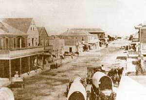
Indianola, Texas, then and now.
The current (5/06) photo below may not be the same street shown
in the photo above, but it is now the only street
along the bay front.
Incorporated as a town in 1853, Indianola's roots were first set at Indian Point, three miles to the north of Powderhorn Bayou. At Indian Point, an American settlement had sprung up in 1846 a year after Texas had become a state. Two years earlier in 1844, Prince Karl Solms Braunfels had begun to land German immigrants nearby at the settlement of Karlshaven also on the shores of Matagorda Bay. By 1848, Indian Point was the primary entry port for European immigrants and Americans landing here to migrate westward.
From Indian Point a major road lead westward to San Antonio and onward to Chihuahua, Mexico. This was known as the Cart Road since oxcarts were heavily used by Mexican and American freight haulers to transport goods into the interior of Texas and Mexico.
In 1853 Indianola was located on Matagorda Bay and Powderhorn Bayou where it had been relocated to take advantage of deeper waters to accomodate steamships of Morgan Lines that had chosen this area due to ease of access from the Gulf. Ships could enter the bay through Pass Cavallo and sail to Indianola in a matter of hours. The route to Indianola had very accomodating water depth without the difficulties of passing through hazards of oyster reefs and shallow bars that made the Lavaca port further up the bay a navigational challenge, and a longer trip.
The decision to relocate on the beach front to the vicinity of Powderhorn Bayou, however, made the town more vulnerable to rising waters and storm surge from tropical storms and hurricanes. The elevation at Indian Point is greater by several feet than the townsite of Indianola. Indian Point is also nearer Magnolia Beach which has significant elevation over either of the two and could have offered protection to residents from the storm surge that inundated their town. The road leaving Indianola would have been submerged by the rising bay water when the hurricane approached, leaving the residents no choice but to ride out the storm in their homes only a few feet above sea level.
The hurricane of September 1875 inflicted extensive damage and loss of life in the town and it was only partially rebuilt by locals unwilling to concede to the forces of nature. Only 11 years later in August of 1886 another hurricane brought havoc to this area of the Texas Coast and an end to this once prosperous frontier seaport. (See the Morgan Lines wharf after the 1886 hurricane).
Home | Historical Marker for the City of Indianola
Copyright 2006-14 - IndianolaTx.com - All
rights reserved.